Sunday, May 6, 2012


Une excursion dans l'outback  //  An excursion in the Outback

Du 26 au 29 avril, 2012

Depuis longtemps, j'entends parler de l'outback, cet immense arrière-pays aride, désertique et isolé de l'Australie. Enfin, j'ai la chance d'y faire une brève visite. En plein milieu de ce continent austral, en plein désert, à 952 kilomètres du grand centre le plus proche, il y a une roche que tout le monde veut voir. Une roche à laquelle, les indigènes (ainsi qu'un grand nombre de touristes) attribuent des qualités surnaturelles. Il s'agit d'Ayers Rock d'après le nom européen, ou Urulu, selon les indigènes australiens.
En décembre dernier, Don avait réservé l'hébergement et le forfait pour visiter ce rocher et King's Canyon, un autre point d'intérêt dans le même coin. Moi je me suis envollé de l'aéroport de Cairns pendant que Don et Pixie prenaient l'avion d'Adelaide pour nous rencontrer tous les trois à l'aéroport d'Alice Springs. Cette ville en plein désert, abritant 27,000 habitants y compris 1400 membres des forces armées américaines est le point de départ pour des milliers de touristes qui  visitent la roche. Nous laissons nos bagages à l'hôtel et allons faire une visite chez Emu Tours pour confirmer nos forfaits des deux prochains jours.
À 6 h le lendemain, un autobus de 24 passagers nous cueille, et dans les prochains deux jours nous couvrirons 1420 km avant de retourner à  notre point de départ. Notre destination aujourd'hui, c'est King's Canyon. Notre chauffeur et guide, Calvin, parle sans cesse, et nous fait rire. Il nous renseigne sur la flore, la faune et les mythes indigènes et sur les remèdes qu'ils ont découvert dans leur milieu. Mais de temps à autre, il nous tire la pipe. Par exemple, il nous parle de l'arbre des soutiens-gorge. Il faut que les membres de notre autobus décident entre eux laquelle des femmes va sacrifier sa brassière pour l'accrocher à cet arbre renommé ... Évidemment, il n'existe pas de tel arbre. Plus tard, il nous décrit l'arbre de caoutchouc mystérieux, appelé Centralian Rubber Tree et explique comment il est devenu un site de révérence pour les indigènes et les touristes. J'ai réussi à le capter en photo sur le vol, comme vous verrez plus bas. Nous arrêtons à Erldunda, à mi-chemin, pour un repos. Puisque j'avais oublié mes 4 bouteilles d'eau dans le frigo de l'hôtel, j'achète une bouteille de 1.5 litre pour l'équivalent de $7.00 en monnaie canadienne.
Rendu à notre destination de la journée, Don opte pour faire le sentier d'un kilomètre par lui-même, tandis que Pixie et moi choisissons de suivre Calvin pour le tour commenté de sept kilomètres sur trois heures. Don avait déjà vu le Grand Canyon aux États Unis, donc un petit canyon comme celui-ci ne le passionnait pas. Je pourrais en parler longuement, mais les photos vont tout vous dire. Au cours de la marche, Calvin nous explique la flore qui tient mordicus à la vie malgré les conditions arides. Parfois il n'y a pas de pluie pendant dix ans, et malgré ça il y a une foule d'arbres, arbrisseaux et d'herbes qui survivent et qui permettent à un nombre surprenant d'animaux d'y faire leur habitation. Mais ce qui est différent de l'habituel, c'est que lors de notre visite, tout est vert. Dans les dernières semaines, le centre du continent a reçu une quantité record de pluie, ce qui a redonné vie au désert. Ce qui est particulièrement intéressant à propos de cette région, c'est la foule d'utilisations que les indigènes on apprit à partir de ces plantes, et comment ils se sont adaptés à un environnement austère. Ce soir nous couchons à Erldunda pour être plus proches d'Ayers Rock demain.
C'est un autocar de 55 places qui nous ramasse ce matin, et il est mené par deux australiens qui se partagent le travail de chauffeur et de guide. Nous ne commençons pas par Ayers Rock, mais plutôt par les Kata Tjuta. De loin, ça ressemble un peu à la roche iconique que nous irons voir après, mais celle-ci est composée de plusieurs segments arrondis. Celui-ci est plus plus intéressant à mon avis, de par ses formes variées.
Enfin, on arrive au but.
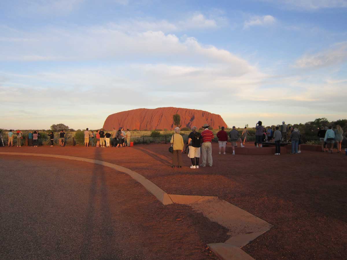
Cet immense monolithe rouge qui ne peut avoir été déposé là que par la volonté d'un esprit tout puissant, d'après certaines croyances, doit nécessairement avoir une influence sur le quotidien de ces premiers habitants, les Arrentes qui vivent sous son ombre depuis 30,000 ans. Haute de 328 mètres, elle domine le paysage et est devenue un des plus grands attraits touristiques du pays. Les indigènes ont obtenu du gouvernement, par le biais d'un traité spécial, le contrôle des allées et venues et des revenus générés par cette manne tombée du ciel. Leurs croyances interdissent l'accès à certaines parties de la roche, comme la caverne d'accouchement. Anciennement, les femmes y allaient avec leur sage-femme pour donner naissance à leurs enfants. L'accès était strictement interdit aux hommes, et encore aujourd'hui les touristes n'ont pas le droit d'y accéder ni même de prendre des photos de cette ouverture en forme d'utérus dans la paroi, sous peine d'une amende de $5,000. Un de nos guides conduit l'autobus jusqu'au rocher et l'autre nous accompagne à pied quelques centaines de mètres; l'autobus nous ramasse plus loin, nous conduit un autre petit bout; nous marchons encore une section et le guide nous raconte les mythes que les Arrentes avaient inventés au sujet d'Urulu, et en deux heures, nous faisons le tour complet de la géante mystique. Notre guide, comme les Aussies en général a un sens d'humour, et nous tient réveillés avec ses commentaires mordants.
J'avais le choix, au lieu de faire le tour de la roche, de la grimper. Et étant grimpigneur, cette option me tentait. Quoique les Arrentes nous demandent de ne pas y monter, par respect pour leur tradition, ils n'interdisent pas l'ascension du grand monument naturel. Ma conclusion, c'est que s'il y avait une interdiction de grimper au sommet, cela ferait du mal à l'industrie touristique lucrative qui leur amène de gros sous. Mon choix de rester sur terre plate était motivé par l'avantage d'entendre les commentaires d'un guide. À la fin de la marche, nos guides nous débarquent dans un grand stationnement vis-à-vis la roche, et préparent notre souper, un barbecue. Quand Don avait réservé le tour en décembre, il s'était fait dire qu'on nous présenterait trois viandes locales cuites sur charbon de bois, soit le kangourou, l'ému et le crocodile. C'était peut-être un résultat du sens d'humour australien, mais la viande qui a accompagné nos salades, c'était de la saucisse BBQ.
Nous attendons le coucher du soleil, et graduellement nous observons le monolithe tourner progressivement du rouge pâle, au foncé, au mauve, au violet et au gris. Nous embarquons pour ensuite voyager les 463 km qui nous séparent d'Alice, et nous arrivons à notre hôtel à minuit. Le lendemain, après une petite balade en ville, nous prenons l'avion pour Adelaide, la capitale de l'état du South Australia, sur la côte sud.

&&&&&&&&&&&&&&&&&&&&&&&&&&&&&&&&&

From 26 to 29 April, 2012

All my life I've been hearing about the Outback, that vast, arid, isolated back country of Australia. At last, I'd have the chance to find out what it's all about. Smack in the middle of the Austral continent, in full desert, 952 kilometres from the nearest big city, there is a rock that everybody wants to see. A rock to which the aborigines (and a large number of tourists) attribute supernatural qualities.
Last December Don had booked our lodging and the tour to visit the Rock and King's Canyon, another point of interest in the same corner of the world. I took off from Cairns while Don and Pixie flew from Adelaide for the three of us to meet in Alice Springs. This town of 27,000 souls, which includes 1400 members of the US armed forces, is the launching pad for tourists who visit Ayers Rock. We drop off our bags at the hotel and walk over to Emu Tours Company to confirm our tour for the next two days.
The following day, a 24-passenger bus picks us up and in the next two days we will cover 1420 kilometres before returning to our kick-off point. Our destination today is King's Canyon. Calvin, our driver/guide talks non-stop but his sense of humour keeps us awake. He informs us about the local flora and fauna, about the aboriginal myths and medicines they derived from their environment. But once in a while, he would pull our leg. Like the one about the bra tree. He told us that between us passengers, we would have to nominate a woman to sacrifice her bra to be hung in the famous bra tree. Of course, there was no such thing as a bra tree. Then there was the Centralian Rubber Tree. He explained the special mythical properties of this special tree and how it had become a subject of reverence for natives and tourist alike. I was able to snap a photo of this tree on the fly, which you can admire below. We stop for a rest at Erldunda, the halfway mark. Because I had forgotten my four bottles of water chilling in the hotel refrigerator, I had to buy a 1.5-litre bottle of water for the equivalent of $7.00 in Canadian currency.
Once at King's Canyon, Don chooses to do the one-kilometre trail on his own, while Pixie and I opted for the three-hour, seven kilometre guided tour with Calvin. Don had seen the American Grand Canyon and figured he wouldn't get much out of the longer trail. I could write at length about this marvel of geology, but I'll let you get what you can from the pictures below. Along the trail, Calvin describes the plants that hang onto life throughout periods of up to ten years without rain. In spite of this aridity, a large number of trees, shrubs and grasses eek out a living and survive till the next downpour. And these in turn allow numerous animals and insects to live as well as the aborigines, at the top of the food chain, who have been living here for 30,000 years. What is special today, and most tourists who come here don't see it, is how green everything is. There has been, exceptionally, a lot of rain in the past few weeks, and the desert has come back to life for a while. Tonight we return to Erldunda to sleep, so that we can be closer to Ayers Rock tomorrow.
A 55 passenger bus picks us up at our hotel this morning. It is manned by two australians who share the jobs of driver and guide. We don't go directly to Ayers Rock, but make a stop at Kata Tjuta. From a distance it resembles the iconic rock that we will be seeing next, but this one is made of many rounded segments. Actually I find it more dramatic, as it has a more interesting shape, in my view.
At last, we reach our goal of the day.
This immense red monolith can only have been put here, it is believed, by the will of a very powerful spirit and must necessarily exert a strong influence on the daily life of the first people who inhabited this region, the Arrentes. The Rock, with its 328 metres in height dominates the landscape and has become one of the biggest tourist attractions of all of Australia. Through a special treaty with the government, the indiginous peoples have obtained control of the comings and goings into the Urulu Park as well as the income from the large number of visitors who leave behind a $25 entry fee. Because of the sacredness of the rock, the Arrentes restrict access to certain parts, like the birthing cavern. In previous times, the women gave birth to their babies in this cave, a deep indentation in the side of the rock, and access was strictly forbiden to the men. Even today, tourists are denied access to and are not allowed to take photographs of this uterus-shaped opening in the rock subject to a $5,000 fine. One of our guides drives the bus further along the base of the Rock while the other leads us along for a few hundred metres on foot while explaining the superstitions of the ancient peoples; the bus picks us up further, drives us to a spot a little beyond; we walk another section while the guide tells us about the Arrente myths and stories about the creation of the mystic giant stone.
I had a choice. I could either go for a guided walking tour around the rock, with the help of the bus, or climb to the top of the mountain. Even though I enjoy climbing up things, I chose the former option, as I felt it would be more instructive, and it was. I think the Arrentes' decision not to forbid climbing might be motivated by money, since putting a restriction on climbing would hurt the tourist industry here. After the walk around, our guides drive us to a large parking lot and take out their barbecues and lay out the buffet. When Don made the reservation in December, he was told that the BBQ would consist of three local meats: kangaroo, emu and crocodile. Maybe it's another quirk of the Australian sense of humour, but the salads were accompanied with barbecued sausage!
We wait for sunset, and gradually the monolith turns color progressively from pale red to dark red to mauve to purple to grey. After supper, we board the bus to cover the 463 kilometers that separate us from Alice, and we get there at midnight. The following day, after a short walk downtown, we catch our flight to Adelaide, the capital of the South Australia state, on the south coast. 

Mon vol de Cairns à Alice Springs  //  My flight from Cairns to Alice Springs

Notez l'arête qui sépare la ville de la plaine //  Note the ridge that separates the city from the plain

Alice Springs

Une famille indigène  //  An indiginous family

La plaine de l'Outback //  Outback plain

L'outback  //  The outback

Cacatuidé rose  //  Pink cokatoo


 Corymbia aparrerinja dans le King's Canyon //  Ghost Gum tree in King's Canyon

Des plis intéressants dans la roche sédimentaire  //  Interesting folds in the sedimentary rock

King's Canyon

Preuve que cette partie du continent était déjà au fond de la mer  //  Proof that this part of the continent was once under the sea

King's Canyon

Formes intéressantes  //  Interesting shapes

Moi, le plus proche du bord que j'ose aller  //  Me, the closest to the edge that I dare go

Le yipee yipee, bon pour guérir une blessure, mais peut aveugler //  The yipee yipee plant good for curing a wound, but blinding if it gets into the eyes

Une cycadale de 800 ans  //  An 800-year-old Cycad

Il y a plus d'un million de chameaux sauvages en Australie //  There is over one million feral camels in Australia

Emu

Lac salé  //  Salted lake

L'arbre de caoutchouc Centralian  //  The Centralian rubber tree

Kata Tjuta

Kata Tjuta
Ayers Rock (Urulu)

Sentier autour de la roche  //  Path around the rock

Une grotte peu profonde//  A shallow cavern

Une "vague"   //  A "wave"

Les points blancs sur le dessus sont des grimpeurs humains  //  The white dots are human climbers

Moi, Don et Pixie après le BBQ  //  Me, Don and Pixie after the BBQ

On attend the coucher du soleil  //  We wait for sunset

Tuesday, May 1, 2012

La Moins grande barrière de corail // The No-Longer-So-Great Barrier Reef


Du 20 avril au 26

La raison pour laquelle Don et moi prenons un chemin différent, c'est que j'ai toujours voulu voir la Grande barrière de corail tandis que mon compagnon est plus intéressé par les villes australiennes dans le sud. Deux mille deux cents kilomètres de long, c'est de loin le plus grand récif corallien vivant au monde. Il est important puisqu'il fournit l'habitat natal pour des centaines d'espèces de poissons et de crustacés. Et ça, sans parler de sa valeur commerciale comme attraction touristique.

La tragédie, et je l'ai constaté de mes propres yeux, c'est que cet écosystème géant est en train de subir une mort à petit feu aux mains de ceux comme moi qui veulent la voir. Excusez la pauvre analogie.

J'ai choisi Cairns parce qu’à cette latitude ici, le banc de coraux est proche du littoral, soit environ 40 km et ce centre touristique offre un grand nombre d'excursions de plongée. J'ai réservé mon forfait au taux de $180 pour une journée complète sur l'eau. Ça comprenait le transport au banc de corail extérieur (le plus beau), l'équipement de plongée en apnée (j'avais mon propre masque et tuba), la collation le matin et l'après-midi et un repas buffet froid et chaud le midi. Mais il fallait payer un autre $7 pour la location d'un habit de lycra pour me protéger contre les cubozoaires (box jellyfish) mortelles.

Le bateau est un catamaran (deux coques) construit en Tasmanie spécialement pour offrir la plongée avec bonbonnes à 64 personnes. Au quai j'ai vu une douzaine de bateaux du genre, opérés par plusieurs compagnies différentes. Le mien n'était pas le plus gros, avec ses 33 m de longueur. Son moteur développe 1300 chevaux-vapeur et consomme 900 L de diesel dans une journée typique, ce qui revient à environ 15 L par personne, ce qui n'est pas trop pire. Mais dans son année record, le banc de coraux (à partir de Cairns seulement) a reçu 1.1 million de visiteurs. Le poison est dans la dose, comme on dit.

Le matin on obtient sa passe d'embarquement au guichet du terminal d'excursions en mer. C'est tellement grand que ça donne l'impression d'un aéroport. En embarquant, on se fait offrir un café et on nous accorde une place pour nos équipements mouillé et sec. Le bateau, avec sa coque planante est très vite, et met environ une heure à rejoindre son mouillage près du récif.

Même si j'ai fait ma qualification pour la plongée SCUBA quand je demeurais à Guelph dans les années 80, j'ai opté pour la plongée en apnée. Je doutais de ma décision jusqu'à ce que je voie les trois endroits où le bateau a mouillé. Le plus profond que les plongeurs ont descendu c'était 8 m, et je crois qu'il n'ont pas vu grand-chose de plus que moi pour leur $60 additionnels. Bon, vous voulez savoir ce que j'ai observé? Beaucoup de beaux poissons de couleurs hallucinantes et de formes allant de l'ordinaire au très bizarre. Mais les coraux eux n'avaient rien de la splendeur de ceux que j'ai vus à Cayo Largo, Cuba, dans les années '70.  Beaucoup de débris de corail parsemaient le fond, entre les colonies de coraux et l'eau qui aurait dû être limpide était trouble.

Les compagnies qui offrent ces forfaits sont très bien organisées et mettent en tête de liste la sécurité. Lorsque les clients sont dans l'eau, plusieurs instructeurs sont là pour s'assurer que tout se passe en sécurité et quatre sauveteurs font la garde constamment. En plus, une chaloupe est prête à se lancer au secours d'un nageur en difficulté. Et avant de lever l'ancre, le capitaine et le maître plongeur font un décompte des clients pour s'assurer de ne pas laisser derrière un autre couple comme dans le film "Open Water ".

Ma visite à Cairns avait un deuxième but. Ici on se trouve à 2072 km au nord de Sydney à vol d'oiseau, au 17e parallèle, dans une région tropicale. Quoique presque tout le continent est quasi désertique, le nord reçoit beaucoup de pluie, qui a donné naissance à une grande forêt humide. Cette forêt contient une très grande variété de flore et de faune, dont un grand nombre d'espèces ne sont trouvées nulle part ailleurs.

Le lundi c'était pour un tour guidé dans le Daintree National Park et Cape Tribulation. Nous prenons la route Captain Cook highway et je m'émerveille devant la route et le paysage côtier qui passe sous mes yeux. On commence au Parc national Daintree par un tour de bateau sur le fleuve du même nom. Dans la zone estuaire, là où l'eau salée des marées et l'eau douce de la rivière se mêlent, j'ai vu, dans leur habitat naturel, des bébés crocodiles et une grosse maman sur la rive boueuse, qui s'est faufilée sous l'eau.  En route pour le cap, j'ai vu, entre les branches, un Cassovary, un gros oiseau bleu foncé qui ne vole pas. Le cap Tribulation, lui, nous présente un panorama de toute beauté où la forêt et la mer se rencontrent. Nous étions seulement cinq touristes dans un autobus d'une capacité de 24. L’industrie du tourisme a beaucoup souffert de la crise économique et du dollar australien fort.

Le lendemain, ce fut une journée pour travailler sur mon blogue et pour aller rendre une petite visite au Jardin botanique de Cairns. L'aspect le plus frappant, ce n'est pas la collection de flores uniques australiennes du nord, mais l'architecture du Centre d'interprétation. Il est entièrement revêtu de miroirs noirs. Les arbres qui l'entourent reflètent leur image dans les murs courbés miroités, faisant que l'édifice disparaît dans le décor naturel.

Le lendemain, avant mon excursion à Kuranda, puisqu'il était de bonne heure, je suis allé me promener dans la rue Esplanade, et constater qu'il y avait du monde planté de chaque côté qui attendait. C'était le 25 avril ANZAC Day (Australian and New Zealand Army Corps), l'équivalent de notre jour du Souvenir du 11 novembre. Et la parade commença. Un groupe après l'autre paradait en marche militaire : les vétérans de la 2e Guerre mondiale, la guerre de Corée, la Malaisie, Borneo, Vietnam, Iraq et Afghanistan. Des membres des forces armées, aériennes, marines (dans leurs habits tout blancs) les scouts, les parents de blessés de guerre, des fanfares qui jouaient Waltzing Matilda et des airs militaires. Et la foule applaudissait chaque groupe qui passait.

L'autocar m'emmène en premier au téléférique, le Skyway Cableway.  Je monte seul à bord d'une gondole de 6 passagers. La gondole frôle la cime des arbres tropicaux qui se compétitionnent pour la lumière du soleil. Long de 7.5 km, le téléférique me fait voir les magnifiques panoramas de la forêt tropicale humide et des montagnes. Il y a deux arrêts en route, et chacun m'offre de beaux sentiers bien aménagés qui me permettent de marcher dans la jungle sans effort et sans danger de trébucher sur une plante ou un serpent dangereux. Mon expérience aérienne termine au village de Kuranda, un village artificiel ouvert de 9 à 5 pour les touristes. Je prends un repas dans un resto en ensuite je vais marcher le long de la rivière Baron sur un sentier large et bien entretenu. Je remarque que la rivière avec ses berges boueuses ressemble beaucoup au fleuve Daintree infesté de crocodiles. Je me rappelle qu'ici nous sommes 300 m au dessus du niveau de la mer et me convaincs qu'il n'y a pas de danger de devenir la convoitise d'un croco affamé. Quelques heures plus tard, le sentier me ramène à la station ferroviaire de Kuranda pour le petit train de Cairns.

Le train descend graduellement, de 328 m d'altitude jusqu'au niveau de la mer. Tout au long, une voix enregistrée raconte l'histoire de ce chemin de fer et décrit le paysage qui se déroule sur notre passage. Cette voie ferrée fut complétée en 1891 le fruit d'un exploit d'ingénierie et le résultat de la mort de plusieurs hommes. Elle traverse 15 tunnels, qui ont tous été creusés au pic et à la pelle, 37 ponts et d'innombrables courbes. Elle longe des précipices et des murs verticaux et me présente des scènes époustouflantes. Enfin, on arrive à Cairns et c'est la fin de mon exploration de ce coin du pays.

&&&&&&&&&&&&&&&&&&&&&&&&&&&&&&&&&&&&&&&&

April 20 to 26

The reason why Don and I temporarily parted ways here was because I had always wanted to see the Great Barrier Reef and he preferred to see the south of Australia. At 2200 km in length, the Great Barrier Reef is the largest coral system on Earth. It is very important as a habitat for hundreds of species of fish, as well as its value as a tourist attraction.

The irony, though, and this I've observed of my own two eyes ( well, 1½ eyes), is that by the very act of wanting to see this marvel, we are contributing to its destruction.

I chose Cairns as a launching pad because here the reef is relatively close to shore (40km) and there are a large number of outfits that provide diving and snorkelling
tours. I plunked down $180 for a day's excursion on the outer reef, which is better than the inner one. The excursion included the snorkelling equipment (I had my own), coffee and snacks morning and afternoon and a hot and cold buffet lunch. It didn't include the $7 fee for rental of a head-to-toe lycra suit for protection against the deadly box jellyfish.

The boat is a catamaran (two hulls) custom-built in Tasmania for providing diving excursions for up to 64 people. A dozen or so tour companies cater to this activity and have their large boats moored at the Cairns Marina. Mine wasn't the biggest, at 33 m in length. Its single engine develops 1300 horse power, and consumes 900 L of diesel fuel per outing. If you're thinking greenhouse gasses, this isn't too bad, since divided amongst the passengers it comes to about 15 L per person for a day. However, numbers are what make the poison: During its record year Cairns has taken 1.1 million people on the reef.

On the morning of your tour, you pick up your boarding pass at a terminal the size and appearance of an airport terminal, where each provider has its own desk. Upon embarking, you're fed a coffee and cookies and allocated places for your dry and wet equipment (towel and snorkelling gear). The boat casts off, and then skims across the surface of the water and takes you 40 km to the reef in about an hour and a half. The skipper drops the anchor in about 6 metres of water just a stone's throw from a large coral head just awash.

Although I'm a qualified SCUBA diver, I chose to stick with snorkelling, because I haven't done much diving since I got my qualification when I lived in Guelph in the 1980s. I had doubts about my decision until I saw the spots where the boat was mooring. The deepest the SCUBA divers were going was 8 m. and I think they didn't see much more than I could from the surface. OK, now, here's what I saw: Lots of fish of hallucinating colours and shapes. But the coral held nothing of the beauty of what I saw on a reef two miles out from Cayo Largo in the 1970s. Lots of dead coral debris between the live coral heads. Nobody I've talked to speaks of the dying coral reef. They talk about the need for protecting it, but refrain from describing how bad it has become. However, many research groups have studied the world's reefs. The University of Queensland has put out a study that predicts that at the present rate, the entire reef will die within 50 to 100 years.

The tour companies that offer these excursions are very well organized and put customer safety at the top of their priorities. I guess they don't want a repeat of "Open Water", where a couple was forgotten on the reef and never found. There were several instructors accompanying the divers and four lifeguards posted on the ship watching the snorkellers, at the ready, should someone show signs of distress. And before weighing anchor, the captain and master diver tell everybody to sit still while they make a head count.

My reason for coming to Cairns was two-fold. Here we're 2072 km north of Sydney as the crow flies and close to the 17th parallel of latitude, in a tropical region. Whereas most of Australia is dry, the northern region receives a loads of rain, which gave rise to a great rain forest with its extraordinary variety of flora and fauna, many species of which are found only on this continent.

Monday was my guided tour of the Daintree National Park and Cape Tribulation. Along the Captain Cook Highway, which follows the coast, I was captivated by the beauty of the road. We start at the Daintree National Park with a boat tour on the river of the same name. In the estuary zone, where fresh water mixes with tidal salt water, I'm intruding in the crocodile's home. We see a few baby crocs basking in the sun and a larger one slithering its way down the muddy shore into the water. Our guide explains the role of different plants in the ecological balance.

When we stop on the way to Cape Tribulation, we catch a furtive look at a Cassowary bird in the bush. The cape itself presents a beautiful panorama of sea and mountain. The bus which was made to carry 24 tourists held only five today. The tourism industry in Australia is suffering from the compounding effects of the economic crisis and the strong Aussie dollar.

The following day, departing at 10 a.m. was my Kuranda tour. Since it was early and I had time to kill, I went for a little stroll down Esplanade Street. There were people lined up on either side of the street, waiting, I deduced, for a parade. Since it was the 25th of April, ANZAC Day (Australian and New Zealand Army Corps), I figured it must have something to do with this important holiday. Down Under, and this applies to New-Zealand too, they celebrate on this date what we celebrate on November 11th as Rememberance Day. A few minutes later, I could hear the sound of  a military band belching out Waltzing Matilda.  One after another, marching groups parade down the street: veterans of WW2, Korean War, Malay, Borneo, Vietnam, Iraq and Afghanistan. Members of the army, air force marines (wearing their brilliant white outfits), boy scouts, parents of war casualties and wounded soldiers. Every group that paraded by was welcomed with applause from the crowd.

At the end of a two-hour ride, the bus drops me off at the start of the Skyway Cableway. I climb aboard a six-passenger gondola with large, wrap-around plastic windows, all by myself.  The gondola skims the tops of the tropical trees that compete with each other and myriad other plants for sunlight. The 7.5 km long gondola ride offers beautiful views of the valley at the start, then I'm overlooking the tropical canopy, where thousands of species of plants and animals form part of a balanced ecosystem. There are two stops along the way and each allows me to walk through the jungle on paved paths and on boardwalks with ease and without the danger of stepping on a venomous snake or a man-eating spider.
The aerial ride ends at Kuranda, an artificial town that opens from 9 to 5 for tourists. I put down a light lunch and then skip the shops. Instead, I go for a walk along the Baron River, on a wide, well-marked path. The river and its muddy bank looks eerily like the crocodile-infested Daintree. But I remember that here, I'm three hundred metres above sea level and reluctantly convince myself that there is no danger of becoming somebody's lunch. A couple of hours later the path leads me back to the Kuranda railway station for my return to Cairns.

The train descends continually, from 328 metres of altitude, down to sea level at its destination. All along the way, a recorded voice narrates the history of the railway and describes the scenery that unfolds as we progress.  The railroad was completed in 1891. It was an engineering feat, but resulted in the death of many men while digging the tunnels with pick and shovel. The train passes through 15 tunnels, over 37 bridges and around numerous curves. It defies gravity on some stretches where it skirts a deadly precipice, but presents its passengers with unforgettable scenery. At last, I arrive in Cairns and this marks the end of my exploration of the northern reaches.

Envollée de Canberra à Cairns  //  Flight from Canberra to Cairns

Trottoir vers la Marina //  Boardwalk towards Marina
Le terminal des forfaits de plongée //  Dive boat terminal

Un bateau de plongée //  A SCUBA and snorkelling boat


Le pont arrière. Notez les vagues qui brisent sur le banc de corail dans le plan arrière//  Aft deck. Note the breakers on the reef in the background

r
Relaxation à marée basse //  Relaxation at low tide

Une rue du centre ville Cairns //  A Cairns downtown street

Un arbre intéressant en ville //  An interesting tree downtown

Un beau trottoir à Cairns  //  A pleasant sidewalk
De la canne à sucre prête à récolter  //  Sugarcane ready to harvest

Captain Cook Highway

Un bateau de touristes sur le fleuve Daintree //  A tourist boat on Daintree River

Bébé croco //   Baby croc

Maman va chercher les épiceries  // Mom's going grocery shopping
Oiseau Cassovary bird

Ce qui arrive au Cassowary quand on conduit trop vite - avant et après  //  What happens when one drives too fast


Cape Tribulation

Centre d'interprétation du Jardin botanique de Cairns. La réflection des arbres font disparaître la bâtisse  //  Cairns Botanic Gardens Interpretation Centre. The reflection of the trees makes the building disappear

Sentier dans le Jardin botanique  //  Pathway in Botanic Gardens

La parade du jour d'ANZAC  //  ANZAC parade

La parade du jour d'ANZAC  //  ANZAC parade

La parade du jour d'ANZAC  //  ANZAC parade

La parade du jour d'ANZAC  //  ANZAC parade

Téléférique de la forêt tropicale  //  Skyrail Rainforest Cableway


Vu au départ du téléférique  //  View from cable car near the beginning

La forêt humide tropicale  //  Tropical rainforest

La canopée de la forêt  //  The forest canopy

La chute Baron  //  Baron Falls

La rivière Baron  //  Baron River

7.5 km de vue sur la forêt  //  7.5 km view of the forest

Moi à la station de Kuranda  //  Me at the Kuranda Station

Cairns vu du train  //  Cairns seen from the train

Une courbe raide  //  A sharp curve

Une chute visible du train  //  A falls seen from the train

Un quartier tranquille de Cairns  //  A quiet neighborhood of Cairns


Tuesday, April 24, 2012


Une journée dans la capitale // A day in the capital


Hier, le 18 avril, l'autobus nous a conduits de Sydney à Canberra sous un ciel gris et pluvieux.  Je n'ai qu'une journée entière pour visiter la capitale et le ciel se dégage tranquillement. J'ai commencé de bonne heure le matin avec le musée de la guerre, appelé Australian War Memorial. Trop de bonne heure pour visiter l'intérieur. Est-ce que j'attends une heure? Les parties du navire HMAS Brisbane en exposition me dépriment ce matin, et je décide de profiter de la journée pour voir des choses plus inspirantes.
La ville de Canberra fut l'objet d'un plan d'aménagement urbain spécial, qui met en valeur les édifices et monuments importants de la ville. L'édifice dur Parlement est situé au centre d'un grand cercle dont les artères principales rayonnent. Au bout d'une de ces artères, en ligne droite avec le parlement se trouve le musée de la guerre à plusieurs kilomètres de distance, l'autre côté de la rivière, lui aussi encerclé par des rues concentriques. C'est une ville bien pensée pour les automobiles, avec ses rondpoints nombreux. Mais cette planification urbaine laisse le piéton souvent sans issue face à une artère occupée qu'il doit traverser. Et les rues qui rejoignent les cercles vont dans tous les sens, formant un labyrinthe insolvable.
Je voyais ma prochaine destination, en plein devant moi, à 5 km d'ici. Un grand boulevard, interrompu par le charmant lac Burley Griffin qui le coupe en deux. Le long du boulevard sur ce côté-ci du lac, à tous les 200m, on a érigé des monuments commémorant ceux qui ont participé aux deux grandes guerres et les moins importantes comme la guerre du Vietnam (j'en ai ajouté quelques-uns au bas du post).
Pour moi, ce qui m'intéressait dans l'Édifice du parlement, c'était l'aspect architecture, plutôt que politique. Cette construction est très récente, ayant été complétée en 1988. La voûte principale est couronnée d'une structure quadrupède qui fait une pyramide qui supporte le mât du drapeau national, grand comme un autobus à deux étages. Cette structure sur le toit du parlement agit comme point de repère, visible dans presque toute la ville. Dessiné de lignes droites, l'édifice est beau dans sa simplicité. Le foyer principal me rappelle d'un film futuristique. Le plafond de panneaux lumineux, supporté par quelques douzaines de grandes colonnes en marbre bleu, éclaire un plancher de marbre blanc et noir. Les escaliers qui se font face à chaque bout, aussi sont faits de marbre blanc, et présentent des lignes simples, aux coins légèrement arrondis. Les cadres de portes sont faits de bronze massif, dont le style ressemble à un Art Deco simplifié. Le système politique australien est basé sur le système britannique. La chambre des représentants qui assoit 150 députés est toute bleue, et le sénat qui assoit 76 membres élus est tout rouge et rose, avec aucune décoration. Enfin, je monte sur le toit, accompagné de douzaines de touristes, pour admirer la ville qui entoure ce point central.
Il y avait encore de quoi à visiter. Il fallait que je satisfasse ma curiosité pour la photographie et la peinture au National Portrait Gallery. Les murs étaient parsemés d'images de visages sérieux, sans expression, ce qui me laissait plutôt froid. Il y a seulement une oeuvre qui m'a fait chaud au coeur, sur laquelle je me suis arrêté. C'est une belle peinture de l'Australienne Kay Cottee, debout sur son voilier; c'est la première femme à avoir fait le tour du monde solo, sans escale et sans assistance, en 1988.
Ensuite j'ai fait une petite incursion dans le musée des beaux-arts, the National Gallery of Australia. Malheureusement, toutes les bonnes expositions temporaires venaient d'être retirées : Gaugin, Van Gogh, Cézane, ainsi que des oeuvres de la Renaissance. La collection permanente comprend principalement de l'art indigène et contemporain, et comme je l'ai déjà mentionné, l'art contemporain de m'impressionne pas. Ce qui avait plus de valeur artistique, selon moi, c'était la belle collection de sculptures indiennes présentant des femmes légèrement habillées et démontrant une petite taille et des seins énormes, dans des poses sensuelles. Parmi la faible représentation d'impressionnistes, y avait une des fameuses scènes de nénuphars de Monet sur laquelle je n'ai pas pu m'empêcher de poser mon regard.
Tous ces musées sont dans le même coin, au bord du lac, et en passant, ils sont gratuits. Pas loin il y avait la bibliothèque nationale. Je n'avais pas mis ça sur ma liste, mais quand j'ai vu la grande affiche à l'extérieur de l'édifice, qui annonçait simplement, "Treasures Gallery", je me suis trouvé attiré. En effet, il s'agit d'une exposition permanente de vieux artéfacts, livres et documents, datant depuis 13e siècle. Étant marin, ce qui m'a le plus impressionné furent les cahiers de notes écrits de la main du grand découvreur et cartographe, James Cook et de la victime de la mutinée la plus notoire de l'histoire, le capitaine William Bligh.
Enfin, avant retrouver Pixie et Don pour souper, il fallait absolument aller voir la fameuse fontaine dans le lac, qui lance un jet d'eau 140 m dans les airs!  Demain matin je laisse mes compagnons derrière une semaine pour aller visiter le nord dans la région de Cairns.

&&&&&&&&&&&&&&&&&&&&&&&&&&&&&&&&&&&&

April 18, 2012
Don and Pixie will be going to Melbourne in two days, and I will be leaving for Cairns after my one-day visit here. I started with the Australian War Memorial. It was too early to see the inside. Should I wait an hour? The remnants of the HMAS Brisbane on display and the drabness of the building itself depress me this morning, so I decide to visit more uplifting things.
The city of Canberra's urban planning was designed to highlight its Parliament Buildings and the War Memorial. See map. It is marvellous for automobiles, with its many roundabouts, but not so for the pedestrian who has to negotiate these major thoroughfares, often without sidewalks.
My next destination 5 km away is within sight, at the other end of the grand boulevard that forms a line between the two main points. About half-way, the boulevard is severed by the pretty Burley Griffin Lake. Every 200 m or so along the way, monuments have been erected on both sides of the boulevard to commemorate those who have participated in the main wars that Australia has been involved with. You'll see pictures of some of them below.
The main purpose for my visiting Parliament House was to observe its architectural importance, as opposed to its political reason for being. The building is very modern in appearance. Much marble and wood was used on the interior and all the designs use straight lines, and no decoration. The main foyer is very impressive, even though it is very simple, with its dozens of blue marble columns, its black and white marble floor and its two opposing marble stairways. Doorways are of solid bronze cast in a simplified Art Decco style. The Hall of Representatives, blue in colour, seats 150 members and the Senate, which is red and pink seats 76.
Next is to visit the rooftop, along with dozens of tourists. The main feature, seen from miles away, is the four-legged structure holding the mast for the National flag, which is the size of double decker bus.
I needed to satisfy my curiosity for photography and art by making a quick visit to the National Portrait Gallery. Hundreds of serious, expressionless faces, hanging on the walls leave me cold. What did warm me up, though, was a painting of Kay Cottee, on her boat. She was Australia's darling navigator, the first woman to sail around the world single handed, unassisted, non-stop.
Then a little incursion into the National Gallery of Australia. All the interesting, temporary exhibitions had left, so I missed out on some Gaugin, Van Gogh and Cézane, as well as a previous Renaissance collection. The gallery displays a lot of contemporary art and by now, you know what I think of that. However, it had an interesting selection of Indian statues of half-dressed women with small waists and large bosoms in seductive poses. Amongst the scarce selection of impressionist art was a nice Monet, one of his renowned lily pad scenes.
All these museums are in the same area along the shore of the lake and they are all free. I was going to end my visits here, but a sign caught my attention. It was a large banner posted on the outside of the National Library which said simply: "Treasures Gallery". In fact it is a collection of hundreds of printed and hand-written books and documents dating as far back as the 12th Century as well as personal artefacts of known people. As a sailor, what interested me the most were the personal diaries written by the great navigator and cartographer, James Cook and the victim of the most notorious mutiny in history, the vilified Captain William Bligh,.
Before meeting up with Don and Pixie for supper, I make an obligatory stop to photograph the fountain in the lake, which ejects a jet of water 140 m into the air. Tomorrow morning I'm leaving my travel companions to go off on my own in the Cairns region, in the hot north.

A = Sydney, B = Canberra. 290 km

Carte du centre-ville //  Map of downtown

Le canon conservé du HMAS Brisbane quand il a été détruit après la guerre //Cannon saved from HMAS Brisbane before it was sunk after the war

Monument à la marine marchande //  Merchant marine monument

Monument hellénique //  Hellenic monument

Monument à la marine royale //  Royal marine monument

Monument des infirmières  //   Service nurses monument


Édifice du parlement //   Parliament House

Escaliers du foyer principal  //  Stairways to main foyer

La ville vue du toit //  The city seen from Parliament House roof


Tableau de Kay Cottee sur son bateau //  Painting of Kay Cottee on her boat

Les feuilles d'automne dans l'hémisphère sud //  Autumn leaves in the southern hemisphere

Burley Griffin Lake